
Last updated: 3 November 2026
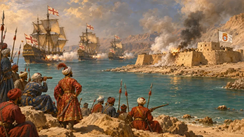
The US strikes reported on Qeshm Island on 2 November 2026 hit the same island where, in early 1622, East India Company gunners helped a Persian army force the Portuguese out of their fort.
As of 3 November 2026, Reuters reported, citing anonymous US officials, that the strikes were limited “defensive” measures taken after Iranian surface-to-air missile fire at US assets, and not a return to major combat. The Pentagon referred questions to US Central Command, which did not respond, according to the Reuters report carried by RTÉ. Iranian state media outlet IRNA reported several explosions on the island. Iran’s Islamic Revolutionary Guard Corps (IRGC) said, through the Tasnim news agency, that it shot down two US drones south of Qeshm that day, as AsiaOne reported. None of these accounts has been independently confirmed.
Most coverage explains what Qeshm is today: tunnels, missiles, a front line in the Strait of Hormuz. Very little asks why this particular island keeps drawing warships. The answer is far older than oil, and it begins with something more basic: drinking water.
By the end of this story you will know why Portugal fortified Qeshm, how an English fleet that had sailed out from Surat in India helped take it in 1622, and why, two centuries later, the ancestor of India’s navy was stationed on its western shore.
Where is Qeshm Island, and why does it matter?
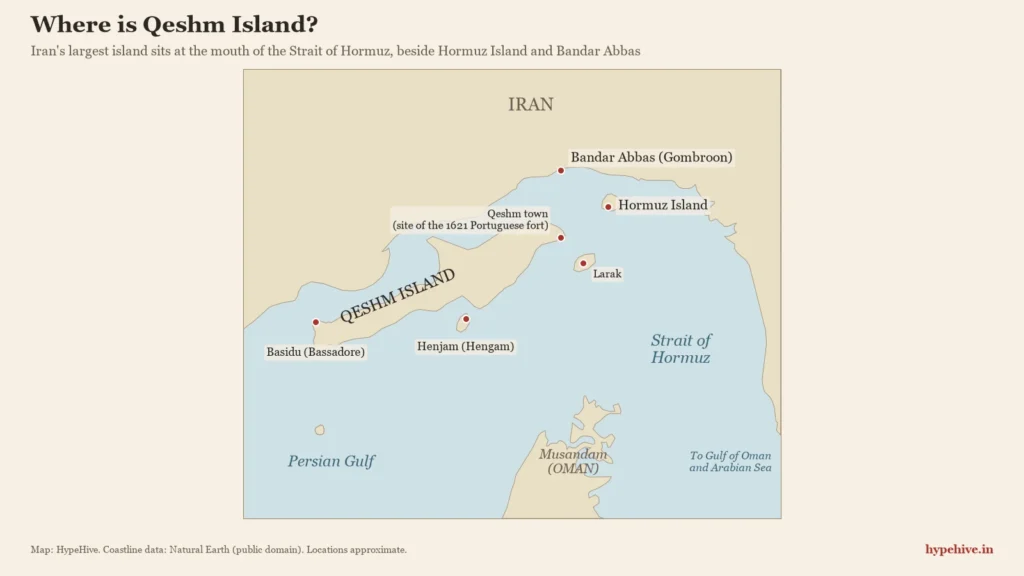
Qeshm is Iran’s largest island, lying at the mouth of the Strait of Hormuz. Its importance began with water: from the 14th century it supplied drinking water to the trading kingdom of Hormuz. Portugal fortified it in 1621 to protect Hormuz, and in 1622 Persian troops and English East India Company ships captured it, ending Portuguese control of the strait.
Qeshm (also spelled Qishm or Kishm) is about 122 km long and roughly 1,445 sq km in area, and it sits about 22 km south of the port city of Bandar Abbas, according to the archaeologist and historian D.T. Potts. Some Indian exam-prep sources give a slightly larger figure, about 1,491 sq km. The island belongs to Iran and lies in Hormozgan province, separated from the mainland by a narrow channel.
The water around it is the most watched in the world’s energy trade. In 2024 about 20 million barrels of oil a day, roughly a fifth of global petroleum liquids consumption, passed through the Strait of Hormuz, according to the US Energy Information Administration. Whoever can watch, block or shelter ships here holds leverage over much of Asia, India included.
Qeshm Island history: the water island that guarded Hormuz
For most of its recorded past, Qeshm mattered because of its small neighbour, Hormuz. From the early 14th century Qeshm was an important dependency of the Kingdom of Hormuz, “often providing drinking water to Hormuz itself”, writes D.T. Potts.
Hormuz was a rich trading city that depended on outside water. It sat on a little island at the throat of the Gulf, where cargoes moved between Persia, Arabia and India, much as goods once flowed through Muziris, India’s ancient Indian Ocean port. When a Tartar attack hit the mainland in 1301, Hormuz’s ruler, Baha al-Din Ayaz, moved his court and much of his population to Qeshm before settling on Hormuz island.
That relationship explains almost everything that followed. Hold Qeshm and you hold Hormuz’s water. Lose Qeshm and Hormuz, however strong its walls, is a city under siege. The first book-length study of the island, Willem Floor and Dan Potts’s Qeshm: The History of a Persian Gulf Island, traces this pattern from medieval Hormuz to the 20th century.
Why Portugal built a fort on Qeshm in 1621
Portugal fortified Qeshm in 1621 to protect the water supply of Hormuz, which it had controlled since the early 16th century. The fort was meant to secure Hormuz; instead it gave Persia a reason to fight.
Portugal had taken Hormuz in the campaigns of Afonso de Albuquerque, first in 1507 and more lastingly in 1515, and made it the hinge of its trade in the Gulf. By the 1610s the Safavid ruler Shah Abbas I had pushed Portugal off the nearby mainland, and Lisbon sent reinforcements.
The commander was Ruy Freire de Andrade, who left Lisbon in January 1619. On 7 May 1621, according to Potts, about 2,000 Portuguese soldiers, backed by 1,000 troops from Hormuz, landed on Qeshm, drove off the Persians and spent the next five and a half months building a strong fort.
Persia’s answer was a blockade. Imam Quli Khan, the Safavid governor based at Shiraz, surrounded the garrison. His aim, Potts notes, was to cut off water and supplies to Hormuz. In effect, the battle for Qeshm was a battle for a water tap.
1622: how East India Company ships helped Shah Abbas take Qeshm and Hormuz
In early 1622 an English East India Company squadron joined Persia’s siege, bombarded the Portuguese fort on Qeshm into surrender, and then helped capture Hormuz in late April or early May 1622. The campaign ended Portuguese control of Hormuz, which had lasted more than a century.
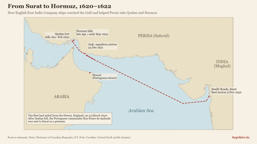
The English ships came to the Gulf from India. The fleet carrying the navigator William Baffin had left the Downs, off England’s south-east coast, on 25 March 1620 and reached Swally Roads, the anchorage of Surat, on 9 November 1620, according to the Dictionary of Canadian Biography. A Company squadron arrived at Jask, on Persia’s coast, on 24 December 1621 to collect silk for export.
The Persians wanted guns and ships, and the Company’s agent in Persia, Edward Monnox, negotiated. J.G. Lorimer’s Gazetteer of the Persian Gulf (1915), compiled for the British Indian government, lists an agreement with the Persians on English co-operation at Hormuz dated 9 January 1622. After talks between Monnox and Ruy Freire failed, the English landed guns and bombarded the fort. The garrison surrendered, and Potts records that Ruy Freire was shipped to Surat as a prisoner aboard the Lion.
Hormuz came next. Company ships bombarded the Portuguese castle and sank the Portuguese vessels anchored there, while Persian troops pressed the siege on land. The garrison gave up in spring 1622 and the Portuguese withdrew to Muscat, as summarised from the work of historians including K.N. Chaudhuri and Joan-Pau Rubiés.
Why did the East India Company join Persia’s war?
The East India Company joined for trade. Shah Abbas needed a navy he did not have; the Company wanted Persian silk and a share of Gulf customs revenue. The Anglo-Persian terms, as summarised from the scholarship, covered dividing the spoils and customs dues at Hormuz, returning prisoners, and Persia paying half the fleet’s supply costs, with the English promised access to the silk trade.
England was not formally at war with Portugal at the time. That made the attack diplomatically awkward in Europe, a reminder that the Company already acted as a semi-independent armed power in Asian waters. That habit was not new: Company ships had fought the Portuguese off Swally near Surat a decade earlier, in 1612.
The death of William Baffin
William Baffin, the English navigator whose name survives on Baffin Bay in the Arctic, was killed during the 1622 campaign. On 23 January 1622, by the English-calendar dates in the record, he went ashore to measure the height and distance of the castle wall so the fleet’s guns could find their range, and he was shot.
Samuel Purchas, who published parts of Baffin’s journals, wrote that he died “in the late Ormus businesse, slaine in fight with a shot”, as quoted in the Dictionary of Canadian Biography. Sources differ on where he fell: that biography places it at Hormuz, while Potts and Lorimer place it at the siege of the Qeshm fort. Lorimer’s Gazetteer reportedly counts him as one of only two Englishmen killed in the Qeshm siege.
When did Portugal lose Hormuz?
Portugal lost Hormuz in late April or early May 1622. Some accounts put the garrison’s surrender on 22–23 April; others give 4 May. One plausible explanation, which we could not confirm, is the 10-day gap between the Julian calendar the English still used and the Gregorian calendar used by the Iberian powers. Until a primary source settles it, “late April or early May 1622” is the honest answer.
What the East India Company won
The East India Company won trading rights and a share of customs revenue in Persia, not territory. According to Lorimer’s Gazetteer, the English were to receive a moiety (half) of the customs at Bandar Abbas, the mainland port the English called Gombroon, in place of those of Hormuz.
The Company held on to that claim for decades. A later East India Company petition to Shah Abbas II, now in the University of Pennsylvania’s collections, asks for the Company’s half of the customs of Gombroon. A University of Kent study notes that the Company’s presence and trade in Persia depended on the privileges of the farman (royal decree) granted after Hormuz fell in 1622.
In money terms, the Persian trade proved modest. Its larger significance is a matter of interpretation, and this is ours: Qeshm and Hormuz showed the Company that armed ships could buy commercial privileges from a powerful Asian ruler. Over the next century and a half, the same Company would turn that lesson into political power in India, financed in part by the bankers who financed the Company’s rise in Bengal.
From Surat to Basidu: when India’s navy was based on Qeshm
From 1820 to 1863, the Bombay Marine, the East India Company’s navy in India, renamed the Indian Navy in 1830, used Basidu on Qeshm as its base in the Gulf. That is the strongest Indian link in Qeshm’s history, and it is almost entirely missing from current coverage of the island.
The arrangement came out of the General Treaty of Peace of 8 January 1820, which, according to Potts, made Basidu (Bassadore), on the island’s western end, the base of the Bombay Marine. The service traced its own origins to a Company squadron that reached Swally, off Surat, in 1612, and it became the Indian Navy by government order on 1 May 1830, according to Royal Museums Greenwich, which holds the archive of the Royal Indian Navy (1612–1947) Association. The navy of independent India descends from this line of service.
The British presence on Qeshm shrank in stages. A detachment of sepoys stayed at Basidu until 1879. By the late 19th century what remained was a coal depot run by a local agent, moved to nearby Henjam island in 1911–12. In 1935 Britain abandoned its coaling station at the request of Iran’s ruler, Reza Shah. Britain’s involvement in Iran itself did not end there, as the story of how Britain helped topple Iran’s government in 1953 shows.
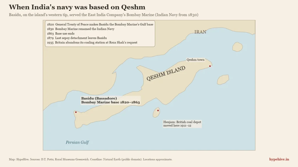
Put the pieces together and a pattern appears. The fleet that took Qeshm in 1622 sailed out from Surat. The Portuguese commander it captured was sent to Surat. Two centuries later, the Company’s navy in India, by then named the Indian Navy, kept its Gulf base on the same island. For about three centuries, much of the outside power on Qeshm came by way of India.
Water, then and now
Qeshm’s water was the prize in 1621, and it has become a flashpoint again in 2026. On 7 March 2026, Iran’s foreign minister, Abbas Araghchi, accused the United States of striking a desalination plant on Qeshm and said water supply to 30 villages was affected, Ahram Online reported. The United States and Israel denied it.
On 31 March an Iranian health ministry official said one desalination plant on the island was out of service and could not be quickly repaired, L’Orient Today reported. Who caused the damage has not been independently verified.
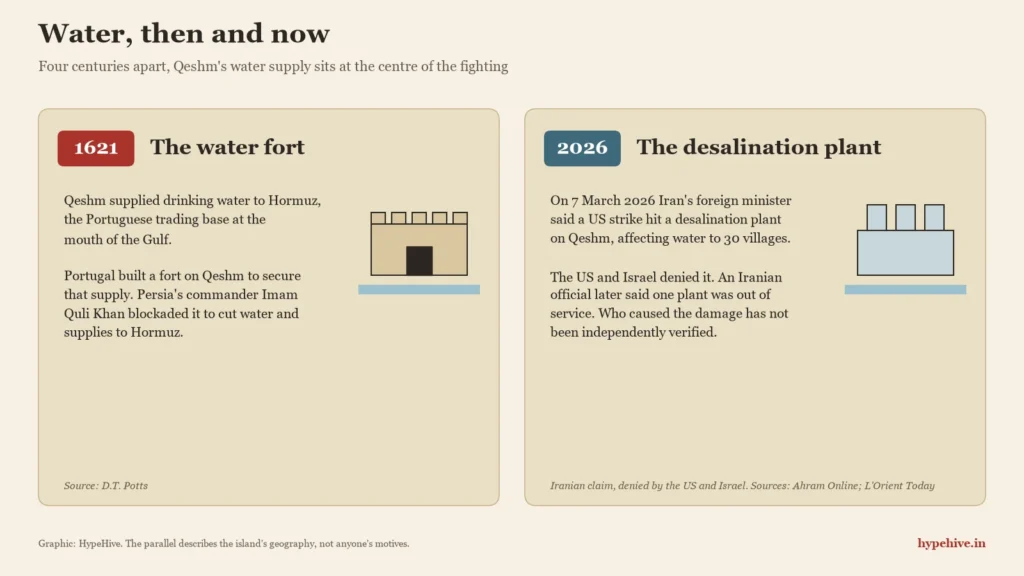
The parallel is not a claim about anyone’s motives. It is a fact about the island: four centuries ago, cutting Qeshm’s water was how Persia squeezed Hormuz; today, water infrastructure on the same island is again part of a war’s story.
What the evidence shows — and what it doesn’t
The core of Qeshm’s 1621–22 history is well documented, but several details remain disputed, and the 2026 events are still unverified. Here is how the evidence breaks down.
- Well established: Qeshm’s role as Hormuz’s water source; the Portuguese fort of 1621; the Anglo-Persian siege; the English bombardment; the fall of Hormuz in 1622; the Bombay Marine’s base at Basidu from 1820 to 1863; the British exit in 1935.
- Disputed: the exact date Hormuz fell (22–23 April or 4 May 1622); whether Baffin died at Qeshm or at Hormuz; the size of the forces, which varies widely between accounts.
- Reported, not confirmed: the November 2026 strikes, described only by anonymous US officials, Iranian state media and the IRGC; the March 2026 desalination plant claim, made by Iran and denied by the US and Israel.
- Interpretation: how decisive English ships were. Persia supplied the army and the siege; the Company supplied naval guns Persia lacked. Historians weigh the two differently, and this article does not claim either side could have won alone.
What we still don’t know: the full English, Persian and Portuguese archival record of the 1622 terms has not been brought together in an accessible form, and the details of what was hit on Qeshm in 2026 are not public.
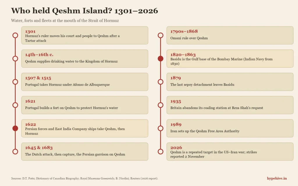
Who has controlled the Strait of Hormuz? A timeline
Control of the Strait of Hormuz has passed from the medieval Kingdom of Hormuz to Portugal, to Safavid Persia with English help, through Dutch, Omani and British intervals, and to modern Iran. Qeshm’s story tracks every one of those shifts.
- 1301: Hormuz’s ruler moves his court and people to Qeshm after a Tartar attack.
- 14th–16th centuries: Qeshm serves as a dependency and water source of the Kingdom of Hormuz.
- 1507 and 1515: Portugal takes Hormuz under Afonso de Albuquerque.
- 1621: Ruy Freire de Andrade builds a Portuguese fort on Qeshm.
- 1622: Persian forces and East India Company ships take Qeshm (early 1622) and Hormuz (late April or early May).
- 1645 and 1683: the Dutch attack, then capture, the Persian garrison on Qeshm.
- 1790s–1868: Omani rule over Qeshm, according to historian Beatrice Nicolini.
- 1820–1863: Basidu serves as the base of the Bombay Marine / Indian Navy.
- 1879: the last sepoy detachment leaves Basidu.
- 1911–12: the British coal depot moves to Henjam.
- 1935: Britain abandons its coaling station at Reza Shah’s request.
- 1989: Iran sets up the Qeshm Free Area Authority.
- 2026: Qeshm becomes a repeated target in the US–Iran war; strikes reported again on 2 November.
Today Qeshm is an operating area for the IRGC’s navy, the force whose wider network we examined through Quds Force commander Abdul Reza Shahlai. For the weapons background, see our history of the Scud lineage behind Iran’s missiles; for the Gulf’s other long-running frontier, read about the Saudi–Yemen border dispute.
Qeshm Island: quick facts (exam-ready)
- Location: Strait of Hormuz, Hormozgan province, Iran; about 22 km south of Bandar Abbas.
- Size: about 122 km long; about 1,445 sq km (Potts), the largest island in the Persian Gulf.
- Historic role: water and food source for the medieval Kingdom of Hormuz.
- 1621: Portuguese fort built by Ruy Freire de Andrade.
- 1622: Anglo-Persian capture, with English East India Company ships aiding Shah Abbas I’s forces.
- 1820–1863: Basidu is the Gulf base of the Bombay Marine (Indian Navy from 1830).
- 1935: British coaling station abandoned.
- 1989: Qeshm Free Area Authority established.
Frequently asked questions
Which country does Qeshm Island belong to?
Qeshm Island belongs to Iran. It lies in Hormozgan province, just off the coast near Bandar Abbas, at the entrance to the Strait of Hormuz.
Why is Qeshm Island important?
Qeshm is important because of its position at the mouth of the Strait of Hormuz and, historically, because it supplied water to Hormuz. Whoever held Qeshm could support or starve Hormuz, which is why Portugal, Persia, the English and the Dutch all fought over it.
Why did the East India Company help Shah Abbas capture Hormuz?
The East India Company helped Shah Abbas I in 1622 for commercial gain: access to Persian silk and a share of customs revenue. Persia had the army but lacked the naval guns needed against a Portuguese island fortress.
Did the East India Company fight wars before it conquered India?
Yes. Company ships fought the Portuguese off Swally near Surat in 1612 and joined the Anglo-Persian capture of Qeshm and Hormuz in 1622, more than a century before the Battle of Plassey in 1757.
Was India’s navy really based on Qeshm?
Yes. From 1820 to 1863, Basidu on Qeshm was the Gulf base of the Bombay Marine, the East India Company’s navy in India, which was renamed the Indian Navy in 1830.
Sources and further reading
- D.T. Potts, “Qeshm Island (In Persian Gulf)”, Iran Chamber Society (courtesy CAIS, SOAS)
- Willem Floor and Dan Potts, Qeshm: The History of a Persian Gulf Island (Mage Publishers)
- J.G. Lorimer, Gazetteer of the Persian Gulf, Vol. I (1915), Qatar Digital Library
- Ernest S. Dodge, “Baffin, William”, Dictionary of Canadian Biography
- US Energy Information Administration, “The Strait of Hormuz is the world’s most important oil transit chokepoint”
